EduServ14 (2016)
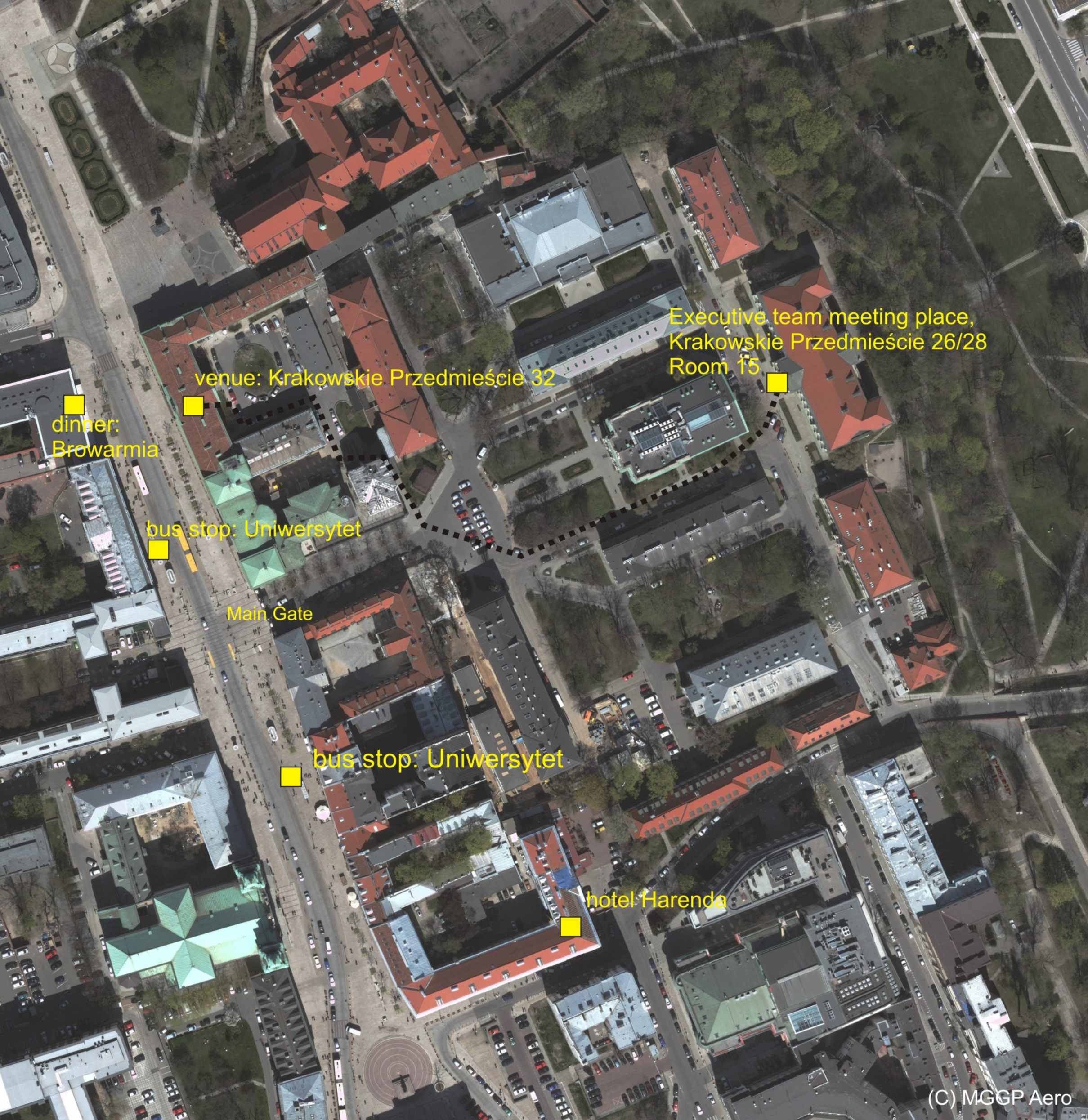
The 2016 series of e-learning courses from EuroSDR will begin with a pre-course seminar, hosted by the Faculty of Geography and Regional Studies, University of Warsaw, Poland, from 7th to 8th March 2016. During the seminar, background material of four e-learning courses will be presented by the tutors, participants will meet the tutors and fellow participants, and the learning platform - Moodle - will be demonstrated. Local organiser of the pre-course seminar is Dr. Bogdan Zagajewski (bogdan@uw.edu.pl). You can find more information about the venue of the pre-course seminar here and the location plan.
The seminar will be followed by four distance e-learning courses, designed for knowledge transfer from the research to the production domain (see details below). EduServ courses can be followed over the Internet from any location, thereby allowing participants to update their knowledge with minimum disruption. Courses require about thirty hours of online study and are completed over a period of two weeks during spring 2016.
RPAS in Land Survey – Theory and Practice (pdf)
Tutors: Dr. Görres Grenzdörffer, University of Rostock, and Dr. Michael Cramer, University of Stuttgart
The course will give an introduction to the use of RPAS and the processing of data. There are significant differences in RPAS imagery – compared to the data which typically are used in airborne photogrammetry, e.g. quality of utilised cameras, irregular image block geometry. Still the quality of the RPAS derived products like surface models and orthophotos may completely fulfil requested demands. This will be exemplarily illustrated compared to the standard reference data from national land survey. Special focus will be laid on the processing of image data from RPAS like application of structure from motion for the image block orientation and dense matching. Furthermore the course will give an overview of the different RPAS carrier platforms and sensor systems and will also illustrate the topic of flight regulations and getting permission to fly.
Dates: 14 – 25 March 2016
International Standards for Geographic Information (pdf)
Tutor: Prof. Wolfgang Kresse, University of Applied Sciences, Neubrandenburg
The course aims at giving a structured perspective at the suite of the ISO/Technical Committee (TC) 211 “Geographic information / Geomatics” and the Open Geospatial Consortium standards and will teach the path from abstract models to implementable solutions for the important fields such as metadata, services, web mapping and imagery. It will focus on the structure of the standards, their content and their interdependence. ISO- and OGC-standards will be discussed as if they belong to the same large model. The course will work on selected applications which build upon the UML-models of existing standards, but require their profiling and an application schema, i.e. decreasing the model and extending the functionality to areas that are not directly covered by the standard. This will be done using UML. The resulting model will be converted to an xml-schema document using the conversion tool ShapeChange.
Dates: 4 -15 April 2016
3D City Modelling (pdf)
Tutors: Prof. Jantien Stoter, MSc. Ravi Peters, Dr. Hugo Ledoux, Delft University of Technology
This is an introductory course to 3D city modelling. 3D city models are becoming an ubiquitous tool in areas such as urban planning and environmental modelling. This course gives an overview on state-of-the-art in 3D city modelling and its applications, introduces the participant to the underlying principles of 3D city modelling and lets them experience hands-on what it means to create a 3D city model. A number of topics will be discussed: the international CityGML standard, the concept of Level of Detail (LOD) in 3D city models, and the importance of data quality. The goal of the practical exercise, to be executed with FME, is to create a valid and CityGML-compliant LOD1 3D city model by combining existing 2D topographical datasets with aerial LiDAR point clouds.
Dates: 18 -29 April 2016
Synthetic Aperture Radar for Mapping Applications (pdf)
Tutor: Prof. Olaf Hellwich, Technical University Berlin
The course gives a complete introduction to Synthetic Aperture Radar (SAR). The paging geometry and radiometry are explained using examples from currently available sensor systems. Sensor orientation and geocoding are treated from a geodetic viewpoint. SAR interferometry, SAR polarimetry, polarimetric interferometry and SAR tomography are dealt with intensively. Approaches making use of satellite-borne SAR for solving geodetic problems are discussed. Mapping applications are discussed with an emphasis on high-resolution 3D object detection and reconstruction. The required computer vision and machine learning concepts are included. The course is of interest for both beginners in SAR remote sensing as well as advanced learners interested in the use of pattern analysis techniques.
Dates: 16 -27 May 2016
Fees:
- 600 € for pre-course seminar + 1 or 2 courses
- 700 € for pre-course seminar + 3 or 4 courses
- 100 € for pre-course seminar only
The fee for attending the pre-course seminar is 100 €. This fee will be deducted from the course fee in case of later subscription to the e-learning courses.
You can register for the e-learning courses until the 21st of February 2016.
A limited number of scholarships will be available to fully cover the course fee and to partially support the travel costs to the pre-course seminar (up to € 500). The scholarships are intended to Ph.D./Master students and other applicants with no or very limited financial support from their university or public institution. Active participation in all four courses and a successful completion of at least two courses is required from applicants in order to reimburse their travel costs.
In order to proceed with the application:
- Register to EduServ14
- Fill in the application form that includes a motivation letter, information about professional experience and calculation of travel costs. It is recommended to support the application with a reference letter. Both documents shall be submitted to eurosdr@soc.kuleuven.be not later than on 13th December 2015.
Applicants will be informed about the acceptance/rejection of their application latest on 8th January 2016. The approved travel costs will not be refunded before successful completing of at least two eLearning courses the applicant registered for!
For more information contact Ms. Anneke Heylen - eurosdr@soc.kuleuven.be